Space used to control environmental hazards
The Regional image processing and remote detection service (SERTIT) at the University of Strasbourg, connected to Télécom Physique Strasbourg, has a developed a cartography platform for risk analysis that is especially well-adapted to the insurance sector, using satellite data of observation of the Earth.
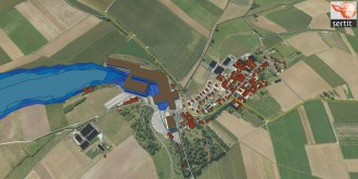
The platform takes the form of a dynamic 3D visualization interface that enables crisis scenarios to be analyzed and their impact on precise locations to be viewed. For this, the researchers had to use a data processing approach that used the full potential of the images, in order to build up the layers of information to create a map that is as detailed as possible. The challenge today is to define users’ requirements and scale data according to these needs.
The Regional image processing and remote detection service (SERTIT) of the University of Strasbourg, connected to Télécom Physique Strasbourg, is a center for technology transfer and promotion managed by Paul de Fraipont. It comprises a multidisciplinary team of 20 specialists covering the field of remote detection as well as a whole array of other disciplines including physics, geometrics, information technology, Earth sciences and topography. Its specialty is the rapid production of geographic information using raw data from observations of the Earth. It provides material for assisting governments, administrations and large corporations in their decision making. SERTIT also works to meet the needs of stakeholders in insurance and reinsurance.

